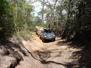
Carrying on North from Coen, we stop at Archer River
roadhouse, nice. Moreton Telegraph station, Bramwell station for lunch &
Bramwell roadhouse is where the Old Telegraph Track (OTT) begins from the South
end. The OTT is the remnants of the original telegraph track, which was constructed in 1880 and the last message was sent in 1962. We were hoping to follow someone else up the OTT track, however there is
never anyone around when you need them. 1230pm and off we go!!!! If any of you
ever do this track, make sure you have all relevant information as there is
nothing at the start of the track and very few signs, (lucky we had brought a
Cape York book in Darwin). North from Bramwell junction the OTT spears through
eucalypt woodland with gallery rainforest's lining the banks of the larger
streams. As the track is no longer maintained there are numerous suspension –
busting gutters & tight corners to negotiate. A major feature being the
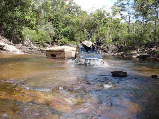
numerous wet creek crossings, many with steep eroded banks & rocky potholes!!
This is not a track to be done unless you are prepared to damage your vehicles.
I have number the crossings from South to North-
Pretty- you may need to zoom in to see all the colours.
A bird of prey?
Driving up the Telegraph track.
Here we go!!!!
1.
Palm Creek- Steep eroded banks, more severe on
the South side, a departure angle of 90 degrees at the bottom, with a narrow
channel, deep muddy water for 30m, a sharp left turn, followed by a Sharp right
turn to a steep ascent. Unfortunately we didn’t quite make the ascent with the
trailer on, we made 90% up, we used our electric winch to pull us the remainder
of the way. We of course walked every crossing before we did them, however some
people on the OTT did not and nearly came unstuck when we were stuck part way!!
At this point I felt sick, my legs were shaking and I really needed a toilet,
and I was only taking the pictures!!!
Looks easy.
Palm Creek in.
Look closely-Steve is standing at the end of the water.
Exit looks ok, apart from you can't get a run up!!
Here come's Steve, Car & Trailer.
Starting to slide!!
Nearly down, into deep thick mud!!
Where's the trailer off to?
Coming round the left bend to firmer ground.
Just got to get out now, from a standing start?
Nearly at the top.
Whoops, stuck!!
The electric winch in use, pulling us up!!
Putting the winch away, all smiles now we are up!!
2.
Ducie Creek – A steep descent (nothing like the
first crossing) on a right turn, through 50m of water, with a large deep hole,
we couldn’t avoid getting to the steep uneven exit.
Walking the crossing.
Here comes Steve.
He's in the water.
A bit of a bow wave happening.
My bed's still dry!!
We came across four boys/men on BMW 1200's.
The reason the OTT is here!!
Steve taking a break on the OTT.
3.
Dulhunty River – This narrow ford is a natural
rock barrage with pretty cascades and large pot holes, it was an excellent
place to camp for the night and swim in the cascades.
A nice easy crossing, across the top of the cascades.
A last knock or two for the trailer & camp for the night.
Steve relaxing in the cascades (Dulhunty River).
Steve relaxing in the cascades after a long day.
Me, Very Happy to have survived our first day on the OTT.
Damage: broke the plastic handle off and bent the pins.
Broken door hinge.
Another broken plastic handle & bent Skirt.
The things you find on the OTT.
4.Bertie
Creek – On entry down the slope, a sharp right turn was needed over large
rocks, to drive along a rock shelf for about 30m, before entering the water and
trying to avoid the large pot holes and rock shelves that await to trap the
unwary.
Bertie Creek, early morning.
This pot hole was just bigger than our ute wheel.
Keep to the right Steve.
Nice work.
Look at the shelf & drop off.
5. Gunshot Creek- Next was a 25klm unnecessary
detour to avoid Gunshot Creek crossing. We went back to Gunshot to spectate and
upon arrival, found there to be a fairly easy route across(chicken run)…Never
mind better to be safe than sorry!! We did stay & watch the BMW motorbikes,
which were the only ones we saw have a go at the severe entry, the pictures
will tell the story of one that just jumped of his bike and let it drop to the
muddy bottom, there was no way he was ever going to make it!! A 2nd
bike did another tricky entry and was fine at the bottom, however he then had to
go through deep water, nearly dropped his bike and took water into the engine!!
Two out of four bikes damaged, the other two took the easy way. After Steve
helped them to get bikes out of Gunshot, we left them and carried on.
A 360 degree shot.
The landscape.
A few holes & cambers to contend with and look at air we get!!
What is the trailer doing?
Infamous Gunshot Creek.
Who would be stupid enough to try this?
Steve passing time until someone more stupid comes along!!
Oh look!! A stupid person!! He jumped off his bike before letting it drop!!
It took four to get the bike out!
Another stupid person, made it down safely and drove through deep water!!
The 2nd stupid person has water in his engine!!
6.Cockatoo
Creek – This crossing had a Croc sign (not good) and yet the book tells you to
walk it first, which we did!! A steep entry with rocks and a drop off, before
you get to the water, several different rock shelves, large potholes &
boulders. A wide water crossing & very deep in parts. An excellent camping
spot. We have now completed the Southern end of the OTT. We do have some damage
only to the trailer, two legs on the trailer are broke, one of the external
doors has a bent hinge & the front box is a bit bent, where we have
bottomed out. We now join the bypass road for 9km to head to Fruit Bat Falls.
Cockatoo Creek.
Steady Steve, watch the boulders & potholes!!
7.
Fruit Bat Falls – This is a scenic highlight on
the OTT. A natural weir that stretches across Eliot Creek a major tributary of
the Jardine River, to form a Croc free swimming hole. Just stunning!!
Spots of rain.
Steve at Fruit Bat Falls.
Steve relaxing at Fruit Bat Falls.
Fruit Bat Falls- stunning!!
8.
Canal Creek – We have now joined the Northern
OTT (South to North). Canal creek is a tricky crossing, a rocky ford with deep
pot holes, in parts it was up to Steve’s waist, the water crossing was about 50 to 60m. A
lot of tourist’s cut in and out the OTT here (so they can say they did the
OTT). We came along 3 vehicle’s, whom had been told this crossing was only knee
deep, well they was aimlessly wandering about in the deep water trying to find
a shallow part, Steve walked the crossing and we went first. One vehicle didn’t
even have a snorkel and the lady was worried about having a wet bed for the rest
of their holiday!! (They made it ok and the mattress didn’t go in the water).
Canal Creek.
Fairly deep, keeping to the right.
Well done!!
I think their trailer was floating.
9. Twin Falls & Indian Head Falls – Another
scenic highlight of the OTT. A short walk from the parking & camp area, two
sets of falls where you can while away a day or two with safe swimming.
Steve at Twin Falls.
Me at Twin Falls.
Steve enjoying the scenery at Indian head Falls.
Indian Head Falls.
Me at Indian Head Falls.
10.
Sam Creek – This descent was just rough, lumpy
and deep in parts. This is an extremely pretty crossing and everyone camps
here, except us!! As we learnt from the previous evening, to avoid large crowds
and screaming kids (why would you bring very young children on this trip?),
just go one crossing further and you get the place to yourselves!!
Camping at Sam's Creek.
Sam's Creek, very pretty.
Nice.
11.
Mistake Creek- There are two options on crossing
this creek, a fairly easy crossing and we saw many 4WD just knock their back
bumper or knock their rear lights out on the drop off!! We opted for the
shorter crossing with the steeper descent into the water. Here there are small
pretty waterfalls where you can safely swim. We spend two nights here, swimming and relaxing
in the falls!! We set up camp, where we had a private path to our own
piece of the creek!! We have
noticed the storm clouds have been building and had spots of rain at Fruit Bat
falls, apparently there is also a severe wind warning for the top end, so we
decide to have a day of and stay at Mistake Creek, where we can swim and watch
other’s do the crossing. However it rained twice during the night & most of
today we have had heavy showers of rain. We have been down to the creek to
watch a quad bike group go through, which was pretty good!! It’s the first time we haven’t been able to
plan anything due to the weather.
Mistake Creek.
Our camper trailer at one end of the path.
Steve getting into our private Jacuzzi at the other end of the path!!
We are so posh!!
Me at Mistake Creek falls.
Steve at Mistake Creek Falls.
Another part of the falls, most people seem oblivious to these falls, as you need to get out the car to see them!! never mind we saw them and played in them for two days.
A quad bike group came through in the rain.
Now it is with great regret for Steve & great relief for me, we leave the OTT behind. We have missed out on Cannibal Creek, steep sides & a clay bottom. Cypress Creek- which is the rickety bridge and Nolan's Brook, a wide deep natural weir, where 50 cars were stranded this season and 30 are still waiting to be recovered!! Not worth the risk!!


No comments:
Post a Comment